
Routebeschrijving
Met de auto:
Voor wie met de auto komt, kan op Google Maps alles vinden wat hij nodig heeft. Tastevins noemt Google trouwens Tastavin, maar dit is dezelfde hameau. Voor het allerlaatste stuk vatten we de route hierbij alsvolgt samen:
zoals je ziet ga je vanuit Les Vans richting Villefort en ga je na 500 m. rechtsaf naar Gravières/Malarce sur la Thines. Na 3 kilometer dalen stuit je op de lange stenen brug over de Chassezac. Aan de overkant ga je linksaf (richting Malarce s/l Thines) en volg je de rivier tot je opnieuw over een brug gaat, waar van rechts het riviertje de Thines onderdoor stroomt en samenkomt met de Chassezac. Voorbij die brug ga je rechtsaf richting Thines over de D513, en volg je de slingerende weg omhoog.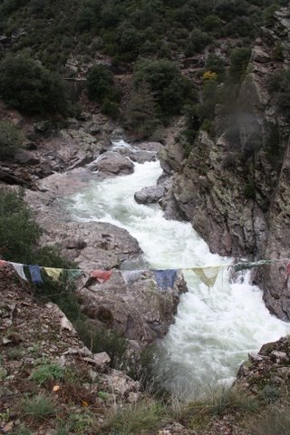 Het loont de moeite om af en toe te stoppen en rond te kijken want je bevind je hier in één van de mooiste en ruigste canyons in dit deel van de Ardèche. Volg de weg voor zo’n 7 kilometer. Nog vòòr Thines kom je op een y-splitsing en daar staat links een bordje waarop richting Tastevins staat aangegeven, met als laatst mogelijke bestemming la Boissière. Je gaat daar links omhoog en volgt de weg – die steeds smaller wordt – tot je twee bruggetjes passeert en voor je neus, naast een garage het bordje Tastevins ziet staan. Je gaat daar links de onverharde weg omhoog naar la Boissière. Na 200 meter, vóór de eerste bocht parkeer je je auto. Je steekt schuin de weg over en volgt het geitenpaadje langs de rivier, die aan je linkerhand stroomt. Na een houten bruggetje volg je de treden omhoog en jawel..daar zie je onze molen.
(de route van Les Vans naar ons is ongeveer 25 km en duurt ruim een half uur)
Voor wie met een GPS rijdt: Noorder Breedte 44°30’21”(44,5560), Ooster Lengte 004°01’45”(4,0294)
Met het vliegtuig
Voor wie komt vliegen, kan met Ryanair een goedkope vlucht nemen van Brussel-Charleroi naar Nîmes of van Eindhoven naar Marseille. Vanaf april vliegt Transavia, iets duurder, van Rotterdam naar Montpellier. Op die vliegvelden kun je een shuttle nemen naar het dichtstbijzijnde station en daar aansluiting zoeken met de trein naar het dorpje Villefort, via het station van Nîmes. (zie hieronder bij de treinverbinding). Vanaf Villefort moet je dan door ons met de auto worden opgehaald.
Met de trein en de bus
Er zijn twee mogelijkheden om een belangrijk deel van de reis per trein te doen, daarna moet je met de bus verder, om tenslotte door ons te worden opgehaald in Les Vans of in Villefort.
Je kunt met de TGV naar Valence TGV, vandaar met de bus verder via Aubenas naar Les Vans. In de maanden juli en augustus rijdt er een extra rechtstreekse Zon-Thalys op zaterdag.
Vanaf http://www.nshispeed.nl/ kun je alle informatie vinden over treinen naar Zuid-Frankrijk.
Over de busdiensten vanaf Valence kun je alles vinden op http://www.ter-sncf.com/Regions/Rhone_Alpes/fr/Default.aspx. Het ‘fiche horaire’ van de bus tussen Aubenas en Les Vans vind je op http://telechargement.ter-sncf.com/Images/Rhone_Alpes/Tridion/74af01_tcm-31-19851.pdf Er gaan niet veel bussen op een dag tot Les Vans, dus bekijk liever eerst de busdienst voor je je trein naar Valence kiest, zodat je een goede aansluiting hebt. Met de auto naar Esprit de la Montagne duurt vanaf Les Vans nog zo’n 35 minuten.
De andere mogelijkheid is dat je een trein naar Nîmes neemt en vandaar naar het dorpje Villefort. Je kunt direct met de TGV naar Nîmes reizen, of in etappes via Parijs en daar de gewone Franse trein nemen. Je moet dan wel nog eens overstappen in Clermont-Ferrand. Je kunt over het Franse traject alles vinden op de site van de SNCF, ofwel op http://www.sncf.com/.
Zoals je zult zien zijn er een paar treinen per dag die Villefort aandoen. Vanuit Nîmes is het ongeveer anderhalf uur daarnaartoe. Het ritje naar Esprit de la Montagne duurt dan nog ongeveer 3 kwartier.
Voor ophalen en brengen vanaf (bus)stations, rekenen we een passende prijs, afhankelijk van plaats, tijd en aantal mensen.
Plan d’accès
En voiture
Ceux qui viennent en voiture peuvent trouver tout ce qu’ils nécessitent sur Google Maps. Tastevin(s) devient Tastavin sur Google, mais c’est le même hameau.
Ci-dessous le résumé de la dernière partie du voyage:
Comme vous voyez, vous allez de Les Vans en direction de Villefort. Après 500 mètres vous tournez à droite direction Gravières / Malarce sur la Thines. Après 3 kilomètres, vous traversez un pont à travers le Chassezac. Une fois traversé, vous tournez à gauche (en direction de Malarce s/l Thines) et vous suivez la rivière jusqu’à traverser de nouveau un pont. A droite vous voyez la rivière la Thines passer dessous et joindre la rivière le Chassezac. Directement après ce pont vous tournez à droite vers Thines. Vous êtes maintenant sur la D513, une route sinueuse que vous suivez jusqu’à l’intersection vers Tastevins pour environ 7 kilomètres. Avant Thines vous arrivez à une intersection en Y. A gauche vous voyez un panneau qui affiche Tastevins et les destinations possibles. Vous montez à gauche jusqu’à la dernière destination de Tastevins: La Boissière. Vous suivez la route qui devient de plus en plus étroite. Quand vous avez traversé deux ponts, vous devez voir devant vous un garage et un panneau qui dit Tastevins. A ce moment là, vous montez le chemin non pavé à votre gauche à La Boissière. Arrêtez-vous avant le premier virage et garez la voiture sur notre parking. Le début du sentier qui mène au moulin sera balisé. L’important est de garder la rivière à votre gauche. Quand vous voyez une grande terrasse et quelques maisons autour, vous êtes arrivés! (la route de Les Vans vers chez nous est à peu près 20 km et dure quelques 35 minutes)
Si vous voyagez avec un GPS, nos coordonnées sont Latitude Nord: 44°30’21”(44,5560), Longitude Est: 004°01’45”(4,0294)
Avec train /bus
Vous pouvez faire une grande partie du voyage en train pour arriver à la gare de Villefort. Après nous pouvons venir vous chercher à Villefort.
Le TGV arrive à Valence, où vous pouvez prendre le car à Les Vans, en passant par Aubenas. Également nous pouvons venir vous chercher là-bas.
Dans les mois de juillet et d’août il y a un Thalys supplémentaire le samedi. Renseignez-vous sur les horaires, les prix et les itinéraires sur www.sncf.com.
Pour vous renseigner sur les cars partant de Valence, visitez http://www.ter-sncf.com/Regions/Rhone_Alpes/fr/Default.aspx. La ‘fiche horaire’ du car entre Aubenas et Les Vans se situe ici: http://telechargement.ter-sncf.com/Images/Rhone_Alpes/Tridion/74af01_tcm-31-19851.pdf. Il n’y a pas beaucoup de cars par jour jusqu’à Les Vans, alors renseignez-vous avant de réserver te train à Valence pour éviter des problèmes.
Le voyage de les Vans à Esprit de la Montagne dure à peu près 35 minutes.
L’autre possibilité est de prendre un train à Nîmes et d’aller de Nîmes au village de Villefort. Vous pouvez prendre un TGV à Nîmes et changer à un train régulier. Le seul changement que vous faites est à Clermont-Ferrand. Renseignez-vous sur www.sncf.com.
Comme vous verrez, il y a quelques trains par jour passant par Villefort. De Nîmes c’est à peu près une heure et demie jusqu’à Villefort et ensuite, le voyage à Esprit de la Montagne dure quelques trois quarts d’heure.
Pour vous faire chercher ou ramener de ou à la gare (routière), nous facturons un prix approprié, selon la distance, le temps et le nombre de personnes.
Itinerary
By car:
It’s not too difficult to find us by car. Google Maps is a very handy tool for that. By the way, Google calls Tastevins Tastavin, but it is the same hamlet. The last 25 kilometers are a bit more complicated, so we’ll write down the route for you.
It starts in Les-Vans, where you’ll have the last possibility to do shoppings. On the central square of Les-Vans you take the direction of Villefort. After 500 meters you take a right turn to Gravières/Malarce sur la Thines. Follow the road for 3 kilometers until you arrive at a long bridge over the large river Chassezac. At the end of the bridge you take a left turn direction Thines/Malarce sur la Thines. For about 7 kilometers you follow this road with the river down at your left side until you cross another bridge where a wild mountainstream, the Thines, flows in the Chassezac.
After the bridge you take a right turn on the D513 in the direction of Thines. From now on it’s climbing up with the canyon of the Thines deep down on your right side.
It’s worth it to take a stop now and then because you’re entering one of the wildest and most beautiful canyons of the Ardèche. Follow the winding road for about 7 kilometers until you arrive at an Y-crossing. On your left side there is a big square sign with the names of the next hamlets. You’ll mar that La Boissière is indicated. Take that – smaller – road going up at the left. You are going for the last two kilometers. On a certain moment after a steep descent you’re passing two little stone bridges and you bump into a barn with next to it the sign Tastevins. On your left you take the little unpaved road going up for 200 meters and right before the first curve you park your car. From now on it’s by foot or with our Landrover. Cross the road and follow the little goat track with the sound of the river at your left. You’ll see there a sign marking Esprit de la Montagne. On your right there is a little wooden bridge. Take that, climb up the stairs and after 100 meters you’ll bump into our little hamlet….
We’ll give you the following GPS-coordinates: Northern Latitude 44 degrees 30 minutes 21 seconds ( 44,5560 ) – Eastern Longitude 004 degrees 01 minute 45 seconds ( 4,0294 )
By plane
The closest airports from Esprit de la Montagne are Nimes Garons, Marseille MP2 and Montpellier. All on 2 to 4 hours driving distance from us. From a lot of European cities you can take cheap flights to these airports with companies like RyanAir. There is for instance a good connection with RyanAir between London Stansted and Nimes.
By train and bus
From these airports you can take a shuttle to the city-center and train station. The nearest train station to our place is the small city of Villefort and from there we’ll have to pick you up. From Alès there is a bus-service to Les Vans, as well as from Valence and Montelimar ( train-stations that are being served by the TGV, the European high speed train ). Also in Les Vans ( half an hour driving from our place) we have to come and pick you up. Note that the bus-services to Les Vans run only a few times a day.
All train-information you can find on the site of http://www.sncf.com
The site of the bus-service from Valence and Montelimar to Les-Vans you’ll find here http://www.ter-sncf.com/Regions/Rhone_Alpes/fr/Default.aspx
Our pick-up service from Les Vans is free. For other trips we ask a reasonable price.

